Abstract
To address the critical challenges of manual land records and paper maps in Pakistan and similar developing countries, this research introduces a novel web-based digital cadastral land information system (DCLIS). Leveraging advanced geographic information system (GIS) capabilities, including map georeferencing, data visualization, and interactive queries, DCLIS provides a robust and accessible platform for efficient land data management. It overcomes the limitations of traditional systems by eliminating time-consuming procedures, minimizing data duplication, and ensuring data integrity through rigorous validation against field measurements (conducted on 20% of cadastral plots) and cross-checking with existing records. By empowering decision-makers in administration (improved land policy planning), land management (streamlined land ownership verification), and agriculture (precision farming, resource optimization), DCLIS facilitates efficient land resource utilization and promotes sustainable development practices. Moreover, its alignment with responsible land management and renewable energy integration contributes to the global drive towards environmental sustainability. This research bridges the digital divide in land record management and paves the way for more informed decision-making, ultimately promoting the development of sustainable land practices in Pakistan and beyond.
Keywords
1. Introduction
Land information system (LIS) is a vital process that encompasses the documentation, maintenance, and dissemination of information related to land administration, including its value, usage, and associated resources[1,2]. This system serves as a powerful tool to enhance administrative, legal, and decision-making processes. It leads to improved economic circumstances, as well as facilitating planning and development[3,4]. The LIS procedure comprises two essential phases. Initially, it involves the gathering of all relevant data pertaining to a specific property. This is followed by the processing, updating, and effective dissemination of land-related information, which is stored in a geographically referenced and organized database[5]. Central to the LIS is the implementation of a uniform referencing system, which forms the foundation for linking various types of data and connecting diverse databases associated with land information[6,7]. Due to the voluminous nature of land-related data, efficient processing becomes essential for timely updates, manipulation, and analysis[8,9]. In response to the need for fair tax collection mechanisms, governments have established Land Administration Systems, encompassing surveying, registration systems, and government-controlled databases to manage land tenures, values, uses, and development[10]. In recent times, the significance of land administration has grown significantly, with modern democracies involving professionals from diverse disciplines to address global challenges related to land security and management[11,12]. This article focuses on the need for a transition from conventional cadastral systems to digitized methods, promoting dynamic land markets, effective land use management, and sustainable development[13,14]. The concept of the ending of cadastral systems evolving on its own has been perceived[15]. To adapt to changing needs, the cadastral system should be customized to foster a dynamic land market and enhance the effectiveness of land use management[16]. Additionally, this customization is believed to play a vital role in promoting sustainable development, economic growth, and social cohesion[17]. To address modern challenges in Geographic Information Systems (GIS) and Information Technology (IT), the conventional system of cadaster mapping must evolve into a multi-purpose approach. This transformation allows the system to efficiently meet the demands of modern GIS and IT applications, enabling better utilization of land information for various purposes[18].
Pakistan, covering an area of 796,095 sq·km and with a population of 216.6 million, has about 62% of its population residing in rural areas, where livelihoods primarily depend on agribusiness[19-21]. In these regions, the key challenges revolve around land accessibility and land rights[22-25]. However, the cadaster and land registry systems in Pakistan, like many other developing countries, face challenges and require improvements[26]. Solidification of the systems is the main requirement and an approach of development based on stimulating procedure. The implementation of improved databases offers enhanced administrative and planning capabilities, clear delineation of land rights, increased potential for economic development, and streamlined policy actions. These systems provide simple and efficient ways to implement changes, ensuring better overall database control All these factors comprise various data sources related to LIS, currently, operational LIS, availability of attribute and spatial data, the structure of the organization is up keeping and maintaining the land-related records, etc.[6,27,28].
2. Digitizing Land Management in Pakistan
LIS is defined as a “tool for legal, administrative, and economic decision-making support, as well as an aid for planning and development, consisting of a database containing spatially referenced land-related data for a defined area, and also procedures and techniques for the systematic collection, updating, processing, and distribution”. Individual land parcels of the published region can be seen interactively with their associated properties. The parcel ownerships, however, have been obscured to protect the identities of the owners[29-31].
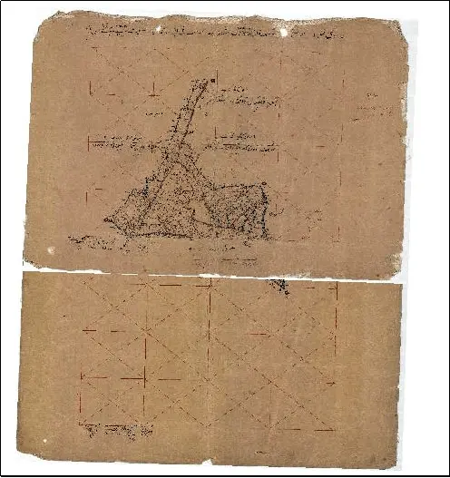
As previously stated, Pakistan’s LIS, which includes land registers and other relevant documents, is built on intricate, obsolete records that are incompatible with current advances. The record is inefficient, with several inconsistencies impeding further developments in the land record system. In Pakistan, the land registry system is administered by the provincial government, and no province has its own data standards[6,32]. These are the units used in the measuring of land parcels, such as the overall size of square feet or acre, and they are not equivalent in different provinces. There are also differences in land or property measuring practices between urban and rural areas. However, according to the basic structure of land registry and cadastral mapping, both these systems are closely associated and interlinked. District, Division, Union Council, Village, area under the village registrar, plot number, reference of land feature, parcel land size, and an address for Parcel Identification. Another component is the land registry which includes: parcel identification address, category of land (private/public), mutation/registration number, mutation/registration date, lease number, parcel area, details of encumbrance, ownership detail, category (commercial, residential, industrial, institutional, agricultural, etc.), address and name of owner, land use and so on. There are three types of land records that are Map of Land Parcel, Field Book (FB), and Ownership Record. The map of the land parcel is the map showing all the existing land parcels of a specific village. Each parcel is assigned an ID called “Plot Number” and plot dimensions. The second important part is the FB which is a data register, established at the time of land settlement. The information in the FB contains the location of the parcel, its dimensions, and parcel ID number establishing the relation of ID for the next parcel record to be entered. This record also has the details of land types in a particular piece of land. OR contains not only the current owner information but the past record of ownership as well. Additionally, the record of farmers plugging on the fields is also available. All three records are relatively compatible because they are simultaneously developed. Despite the fact that records are always changing due to changes in ownership, timely updating of the record is essential. These records are updated every four years in Pakistan. Land records, as well as any related information, are updated and maintained by a government office. A sheet of paper is used to sketch the parcels with their position and size in the traditional approach. The government official is in charge of combining and dividing the parcels on that piece of paper. Figure 1 shows an example of this sort of parcel map. That government official is also in charge of providing information on the various crop varieties planted on every given piece of land. The collection of crop information is scheduled every 6 months and keeps the record in a designated registry[33-37]. This research is an effort to address LIS challenges, and GIS is a technology that can help solve these problems. GIS is a system for collecting data, organizing it, and evaluating its relationship with the geographical distribution. Multiple phases are involved in the management of the land record system. The LIS component of GIS contains a set of GIS data with numerous qualitative and quantitative aspects related to land resources. This system encompasses land ownership, land management, and land analysis. Traditional survey techniques, the global positioning system (GPS), and a defined system for satellite image gathering are all used in the implementation of LIS. The mapping methodology following ground survey or based on aerial survey is used to conduct cadastral survey. As all these operations are completed, they provide digital maps showing administrative boundaries. GPS is used for data collection from the field with a portable backpack for surveyors and handheld devices for ease of use. By linking to satellites, GPS assists in detecting the actual location of the surveyor or the area being surveyed. This location is in the form of coordinates (x, y, z) by just pressing the button of a handheld GPS receiver. The location data is kept in the GPS device, which is retrieved when the survey is completed and can be used directly in the GIS database[11,38-42].
The LIS in Pakistan has been passed down from the British colonial era, including regulations and protocols pertaining to the transaction, acquisition, and utilization of land resources, primarily linked to the gathering of land income data[43]. The existing land legislation system in Pakistan, governed by the West Pakistan Land Revenue Act of 1967 and 1908, as well as the Registration Act, lacks a provision for the acknowledgment of ownership certificates crucial for establishing land title and ensuring public authority protection. Despite the perception that all land records and associated documents are accurate as per legal provisions, court rulings indicate that entries related to land revenue are contestable. It is noteworthy that these revenue records do not explicitly indicate the title of the document, making challenges to land title permissible. The overall assessment reveals that no government entity in the country maintains property records based on title registration, leading to numerous legal disputes that significantly burden the legal system and impede investment processes[44].
The transition from the traditional land records system to a computerized system is currently underway in several provinces and regions across the nation. The entire process is being meticulously managed to establish an efficient LIS that will contribute to the improvement of the land revenue system[45]. The automation will also help eliminate a culture centered around government officials who lack access to computerized or authentic records. This traditional system poses several problems and concerns related to the LISaph[46]. The implementation of Pakistan’s land record system undermines the core objectives of rights records. The current state of manual record keeping has several issues and limitations. As per the manual system, it is important to prepare and update land records along with their corresponding field maps to ensure the link between the records and any physical changes. This activity involves intensive exercise, including field surveys and the recording collective assemblies by the officials of revenue. Lack of attention from higher authorities of revenue, most areas have no proper land records. Due to this, conventional records are being used even with errors and forged entries, and no effort is being made to correct the land records. The computerization of land records started late in Pakistan as compared to its bordering countries, so the haste in implementing this system is the leading factor in errors in land records and diversion from main objectives. In 1988, the automation of land records was launched in India, and it took two decades to finalize the strategy for implementing the computerized land record system in several states based on different phases. The digitized system of documentation will deliver an accurate figure for a big landowner’s property. The system will make the bureaucracy independent, which will then make the overall cycle virtuous. The system will make the common man able to rightfully make his claims without any political influence. They can then cast their vote according to their will, which results in electing an honest and merit-based person into power. In return, the elected person will work fully to ensure the legislation of law and order and independence in the system, which helps in building a well-defined and strong system of accountability.
The LIS in Pakistan is paper-based, organized by a village registrar, periodical crop inspection (Gerdawar), and the officer in charge of revenues (Tehsildar) for village, agriculture, and tehsil-based records, respectively[47]. The outdated paper-based approach in the modern era necessitates computerization, and GIS proves highly useful in this regard by enabling the digitization of the entire system and the storage of data in the form of maps and attributes[48]. Recently in Pakistan, two projects have been done working to make the system computerized one is Participatory Information System in Baluchistan and the other one is Land Record Management Information System in Punjab[49]. The above projects claim to provide facilitation to the public to access and to make transparent land records comprising two provinces in two sites as a pilot project. The Planning and Development Department is responsible to oversee planning related to development. A provisional information system incorporating the GIS interface has been developed for managing information in the pilot project covering Jhal Magsi and Loralai districts, with the GIS interface serving to present data to government officials and communities, aiming to raise awareness of community strengths, weaknesses, and potential development priorities. The LRMIS is established to improve the land record delivery system to reduce trial and long-lasting security tenure. The phase of the pilot project covers the revenue unit in the district of Lahore and was funded through the provincial government, World Bank also shows interest in reproducing it towards other province parts[50].
The project location is Garhi Sikandar Khan near Ring Road in Peshawar District, and the goal is to make LIS computerized[51]. Given the existence of 17 books in Pakistan for maintaining a single parcel record, posing a risk of redundancy and inaccuracies, the initiative aims to enhance efficiency, effectiveness, and accuracy in the system. To mitigate redundancy and errors, GIS technology is being employed to computerize the process[52].
3. Study Area
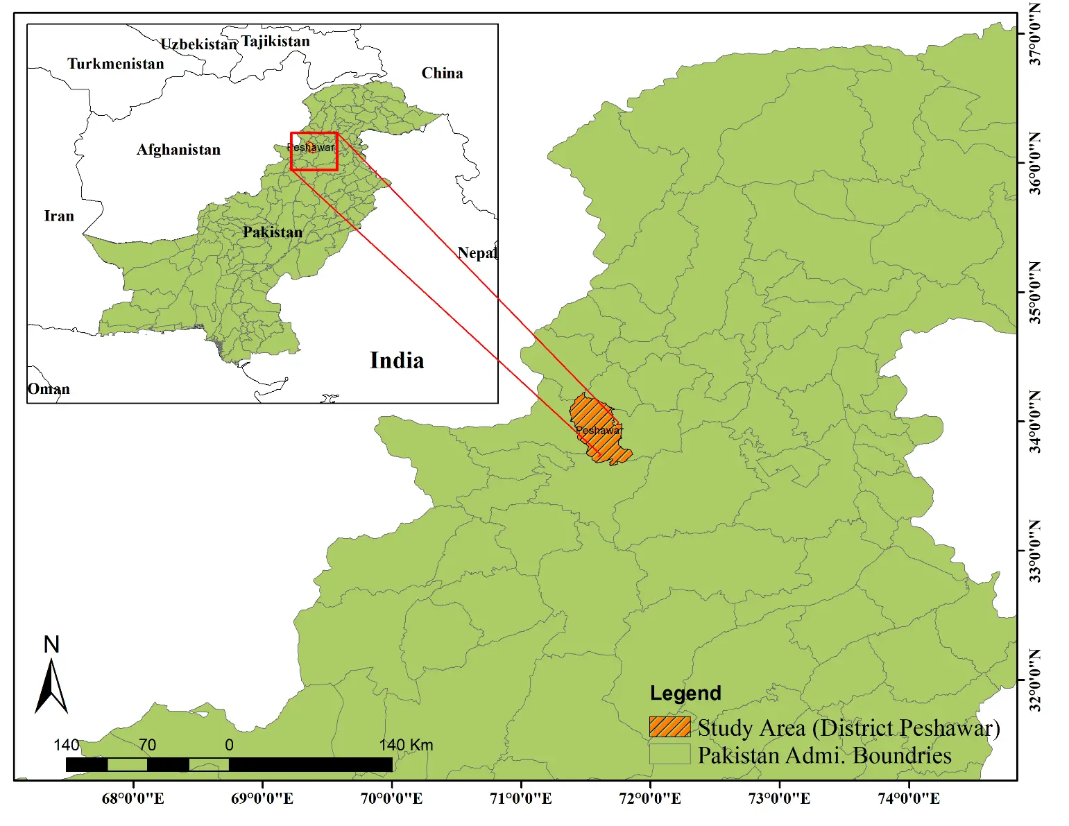
The study area is located in south east of Peshawar district, Pakistan. Peshawar district is the provincial capital of Khyber Pakhtunkhwa, located on the right side of Khyber Pass. The land of the district is a mostly fertile plain. The part of southeast has a tiny hilly area that belongs to the main range of Khattak. The center part of the Peshawar district contains deposits of fine alluvial. The original name of the study area is Garhi Sikandar Khan, which is a village situated on the ring road with a population of 2,467. It has a latitude of 71°31'50" and a longitude of 33°58'8" as shown in Figure 2. The estimated terrain elevation above sea level is 375 meters. Most of the area is covered by settlements and a little area is covered by agriculture. Garhi Sikandar Khan has the following Table 1 population which shows the number of males, females, and the literacy ratio. On the north side of this area is Riaz Shaheed colony, in the South, there is Landi Akhon Ahmad, in the East Shaheed Abad and its west side Manakrao village is located.
| Garhi sikandar khan | |||
| Both sexes | Male | Female | Literacy ratio |
| 2,467 | 1,289 | 1,178 | 70.8 |
Source: District Census Report, Peshawar, 2021.
3.1 Material and method
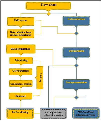
The main goal of this research is to create a reliable LIS using established procedures to ensure accuracy and security in land parcel information and civil rights associated with land parcels. The study seeks to accomplish this objective by converting current land records into a digital format. Our main goals involve the digitization of revenue cadaster maps, linking attribute data to spatial data, and storing land records in a geodatabase. A Web portal (http://mgo.ms/s/11ejl) has been developed to provide convenient access. The study makes use of Easy GPS, ArcGIS 10.5, MS Excel, and the Mangomap server, as shown in Figure 3, which outlines the methodology.
3.1.1 Benefits and outcomes
Pakistan can experience a multitude of benefits in land management by transitioning to a digital LIS. These improvements result in increased accessibility, more efficient processes, and improved accuracy of data, which ultimately leads to greater efficiency and transparency in land record keeping.
• Quick Access: Efficient and swift retrieval of specific records through a search facility.
• Cost and Space Savings: Reduction in costs and physical space required for parcel and registers storage by centralizing data on a single server.
• Expense Minimization: Minimizing expenses associated with physical storage compared to the manual system.
• Data Duplication Elimination: Prevention of redundancies by entering information into a central database, eliminating data duplication.
• Reduced Risk of Data Loss: Online server and regular backups every 24 hours significantly reduce the risk of data loss, even in the event of register damage or theft.
• Precision with GPS and Remote Sensing (RS): Utilization of advanced technologies like GPS and RS for accurate measurements of land parcel size and location.
3.2 Data collection
Revenue data: Data on revenue, including details on land ownership, land use, and field area (Jamabandi) for the year 2010-11 in Garhi Sikandar Khan, were gathered from the revenue office (Muhafiz khana). Furthermore, the revenue office provided traditional paper maps (cadastral maps) of Garhi Sikandar Khan.
Field survey: A field study was carried out in the administrative district of Garhi Sikandar Khan to gather control points for GPS georeferencing of the administrative district map. Figure 4 shows a total of 15 points that were carefully selected from key locations like map corners or road turnings, effectively covering the entire administrative district.

Figure 4. Showing ground control points taken at the field survey and Mosaicked image of Garhi Sikandar Khan.
3.3 Data analysis
3.3.1 Mosaicking and georeferencing
A mosaic is created by combining multiple images into one, which is necessary when there are overlapping areas in separate images that make digitization difficult. The combined image is then utilized for georeferencing, as shown in Figures 5a,b. Georeferencing requires adjusting the image to align with a specific size and position by scaling, rotating, translating, and deskewing it. We collected and merged conventional paper maps of the required administrative district into a single image. We then used the UTM WGS84 Zone 42 North projection system. Figure 5a illustrates the mosaicking process. This paper highlights the importance of digitizing traditional paper maps as a crucial step towards improving data management efficiency. The transformation of analog maps into a digital format enhances accessibility and enables advanced spatial analysis, leading to better decision-making processes, as shown in Figure 5b.
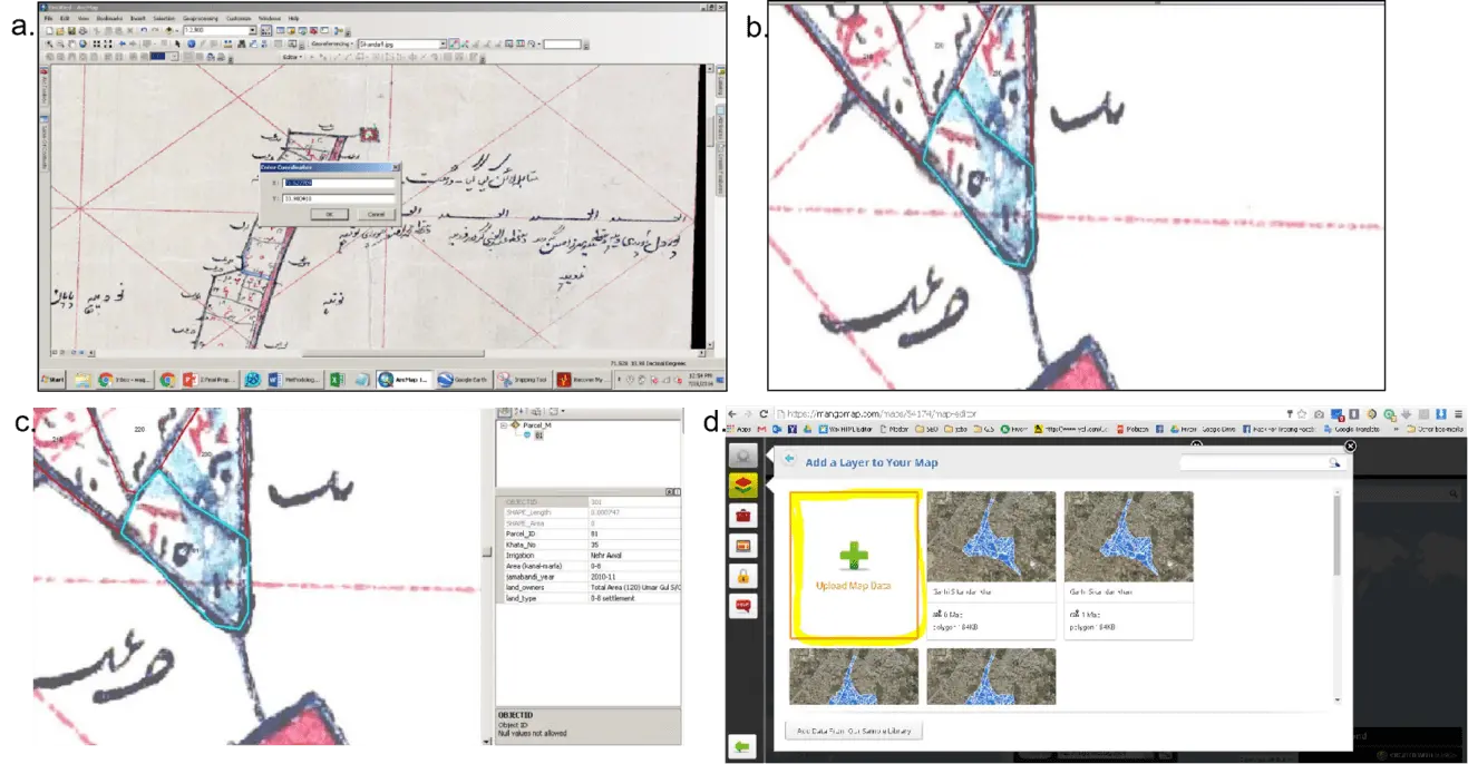
Figure 5. (a) Adding of coordinates to the image for Georeferencing; (b) Digitization of conventional paper map; (c) Cross referencing of attributes with parcel; (d) Uploading of data to the Mangomap server.
By cross-referencing attributes with parcels, a more comprehensive data integration is achieved. This integration enriches parcel information with additional details, leading to improved analysis and decision-making. This is demonstrated in Figure 5c. By uploading data to the Mangomap server, the sharing and visualization of geographic information becomes more efficient. This promotes improved accessibility and collaboration, as shown in Figure 5d.
3.3.2 Geodatabase creation and digitizing
A geodatabase is a useful tool for storing GIS information in a single file. It can hold multiple layers, such as points, polygons, and polylines, making it a comprehensive solution. A file Geodatabase is created to consolidate all layers of the area, including roads, streams, and parcels.
There are two forms of digitization, which involves converting data from hard copy to a digital format. One aspect involves converting paper maps into digital format, while the other centers around the Record of Rights (ROR)/Jamabandi of a village. This record includes information like owners’ names, land acreage, ownership shares, and other rights. For the digitization of conventional paper maps, each parcel was digitized separately using the polygon feature. A unique parcel ID was recorded for each parcel, as shown in Figure 6.
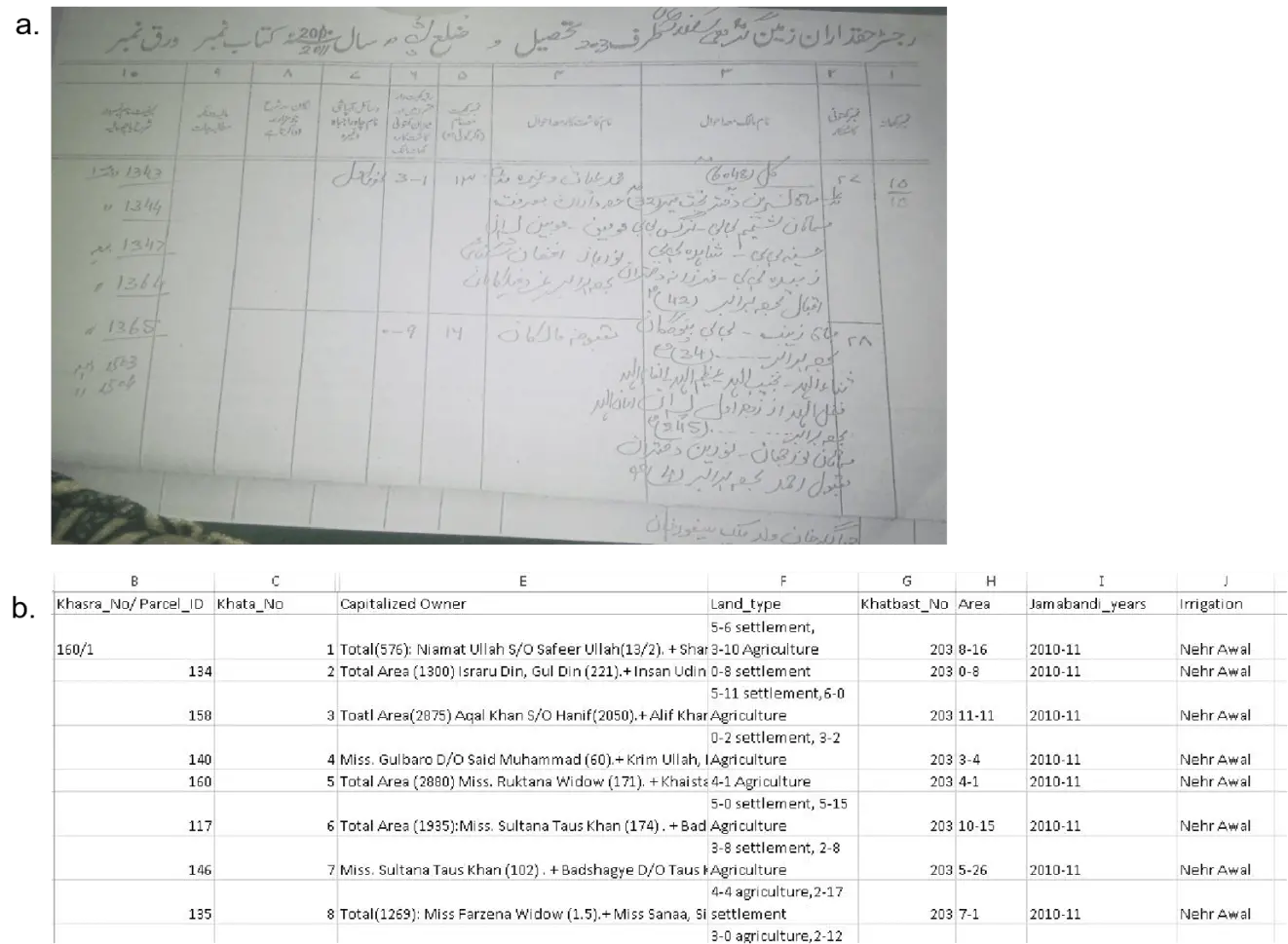
Figure 6. (a) Shows Jamabandi ROR scanned; (b) Shows the converted Jamabandi into digital form. ROR: Record of Rights.
ROR (Jamabandi) digitization requires capturing attribute values for every parcel. The ROR contains various details, including the record number (Khata Number), the number of records for the former (Number Khatoni Kashtkar), the name of the farmer (Kashtkar), the area of the parcel in yards or acres format, the land use of the parcel, and the irrigation source. The ROR (Jamabandi) has been converted into a digital format and is displayed in an Excel sheet, as depicted in Figure 6 below.
The scanned Jamabandi (Record of Rights) offers a digital representation of land ownership and related details, facilitating efficient record-keeping and reference, as depicted in Figure 6a. The conversion of Jamabandi into digital form enhances data storage, retrieval, and analysis, fostering streamlined land record management and improved accessibility, as illustrated in Figure 6b.
3.3.3 Attribute linking and data presentation
As illustrated in Figure 5c, the attribute data was cross-referenced with the parcels using the unique field known as Parcel ID (Khasra No).
3.3.4 Web-based land information system and web-based online server
The Mangomap server is more than just a regular web map viewer. It serves as a vital online portal for county maps and public datasets. The platform offers the ability to manage custom domains and includes a prepackaged portal for public maps and data, making it easy to integrate into existing websites. This platform provides a wide range of functionalities designed to meet the specific needs of researchers and users in the academic context.
3.3.5 Mangomap take data input in the form of shapefile
As a result, start by converting the feature class to a shapefile. The shapefile was then uploaded to the Mangomap server, which interpreted and converted it into a graphical interface that allowed us to quickly inspect the specifics of each parcel. This also has the potential to securely upload any maps to the internet. This server allows users to password-secure any map.
3.3.6 Steps for uploading GIS data to a web-based platform
Choose the “Upload Map Data” button on the layer control button. Select “shp, dbf, prj, and shx” files for uploading since data will not be uploaded if any of these files are missing, as shown in Figure 7a,b. Provide the map with a title and description, as shown in Figure 7c.
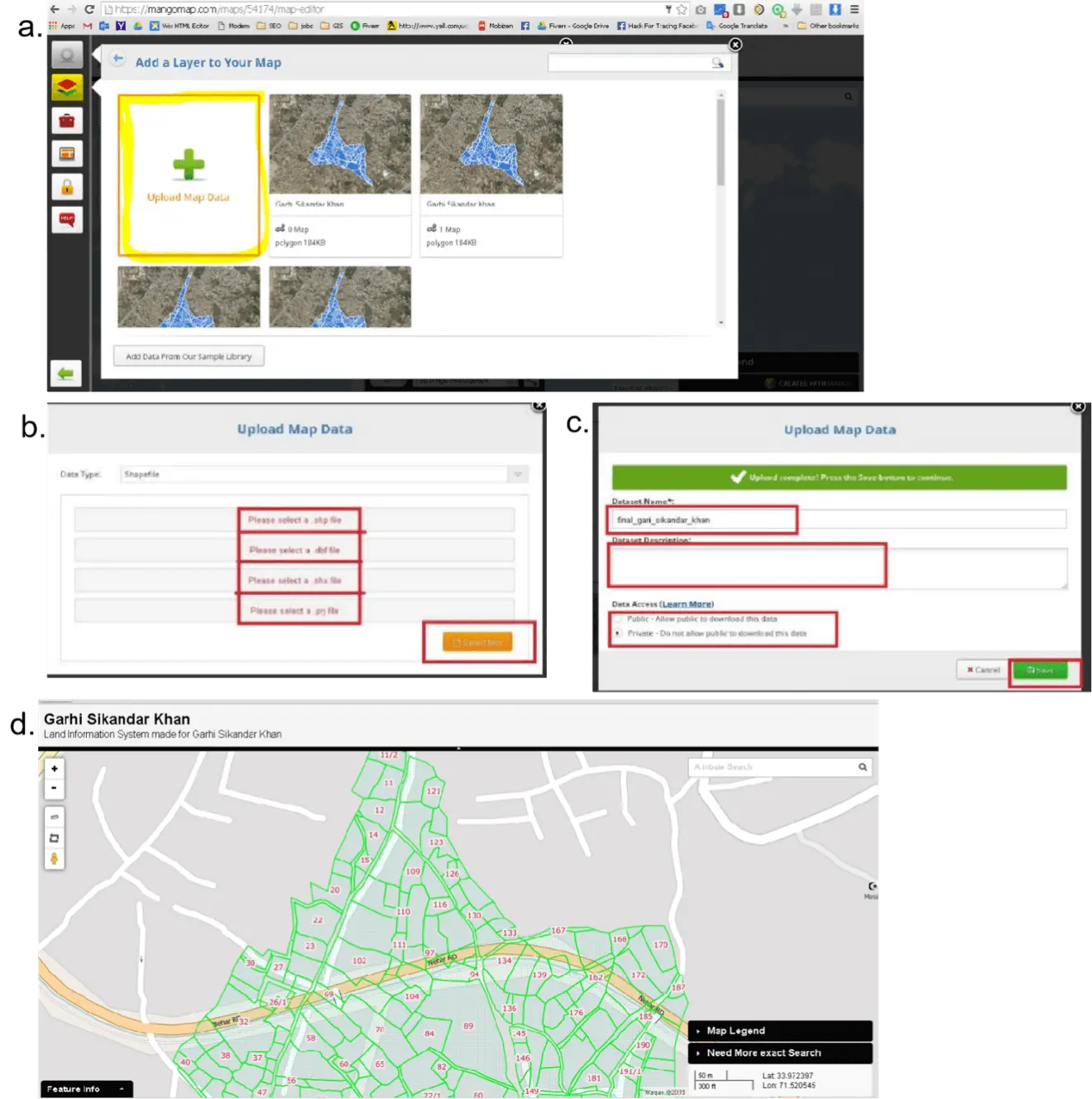
Figure 7. (a) Shows uploading of data to the Mangomap server; (b) Shows the files needed for adding data to the Mangomap server; (c) Shows specifying the title and description for the layer/map; (d) Shows interface of web-based LIS. Lis: Land information system.
4. Results and Discussion
4.1 Digitalization of cadastral maps
The primary objective of this study is to digitize cadaster maps and store the revenue record in a digital format. The process starts by scanning traditional cadaster maps in the initial phase, then proceeds to georeferencing. After being scanned and georeferenced, the maps are digitized and stored as records in a shapefile. Next, you’ll need to include specific attribute information for each digitized parcel. The attribute table of the shapefile is populated with all the necessary information, which leads to the formation of a Geodatabase.
4.2 Developing a web-based portal and its features
After digitizing all cadastral maps, the second objective of this study is to develop a web portal for easy data access. The online server has been successfully developed and can be accessed via the provided link: https://mangomap.com/waqara430/maps/142079/garhi-sikandar-khan?preview=true#. The visualization shown in Figure 7d provides details of interface of web-based LIS.
4.3 Advanced search
This allows you to find the exact value in the specified field if you want to find a record by parcel ID so put that in the parcel ID field as shown in Figure 8c.
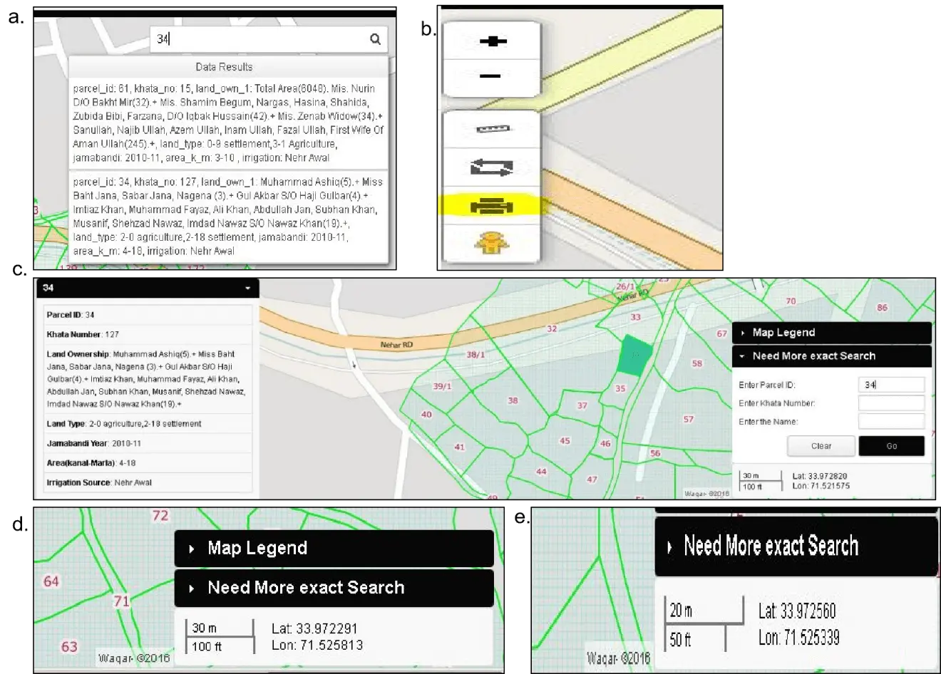
Figure 8. (a) Basic Search tool in the Web-based Land Information System; (b) Print Facility in the Web Portal; (c) Advanced Search tool in the Web-based Land Information System; (d) Lat-long locator tool; (e) Map Scale tool.
4.4 Latitude longitude locator
It has an active latitude and longitude locator as you move the mouse over any point as shown in Figure 8d.
4.5 Advance scale bar
It has an advanced Scale Bar that shows you the exact scale as you zoom in or zoom out the map as shown in Figure 8e.
4.6 Security features
Protecting map data and controlling access are two of the primary goals of the Web Interface’s security procedures, which are detailed in this section. Three security levels used in Web Interface.
Public: The map is accessible to anyone with or without a link. It can also be found via search.
Hidden: This option allows the map to be hidden and can be shown using the link it generates only.
Password: This option allows to password protect the map. It can only be viewed when the correct password is entered. More details on available features in the online web interface are shown in Table 2.
| Available features | |
| Zoom to Maximum | It has the ability to zoom to a scale of 1:420 |
| Zoom to Minimum | Its minimum zoom is 13,800,000 |
| It has the ability to print the desired map of the area we want as shown in Figure 8a | |
| Ruler | It can measure the distance by line in feet or area by polygon in acres |
| Search | It has two types of searches available. One is a basic search and the other is an advanced search |
| Basic Search | It searches the value in any field in the attributes in any place and gives you the results that it matches as shown in Figure 8b |
4.7 Updating of data and records
Mangomap allows users to easily update both attribute and geographic data. To make edits to geographic data, adhere to these steps: First, locate the ‘Layers’ option and proceed to select it. Next, find the edit button, which can be found in Figure 9a. Next, select ‘Open Data Editor’ from the options, as illustrated in Figure 9b. By opening the interface, users can easily update the data, as shown in Figure 9a. Geometry and attributes can be edited by clicking on the “Update Geometry” button shown in Figure 9c,d.
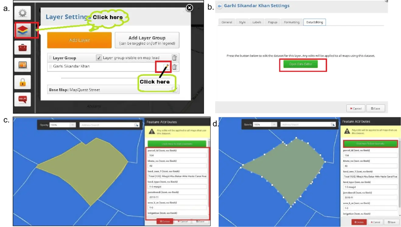
Figure 9. (a) Interface for updating of layer; (b) Button to open the interface; (c) Updating the attributes; (d) Interface for updating geometry.
4.8 Customization
The Mangomap server allows users, the facility of full customization of online map view. Users can customize the Title, Description, Style, Label, Popup, and Formatting as shown in the figures below.
Customizing the title and description enables users to personalize and present geographic data in a clear and relevant manner Figure 10a. Customizing labels enhances the clarity and user-friendliness of geographic features on maps, resulting in improved readability and understanding Figure 10b. Customizing popups improves user interaction with geographic data, offering relevant information and enhancing the overall user experience Figure 10c. Customize the title and description to meet specific requirements, creating a brief yet informative summary of geographic data Figure 10d.
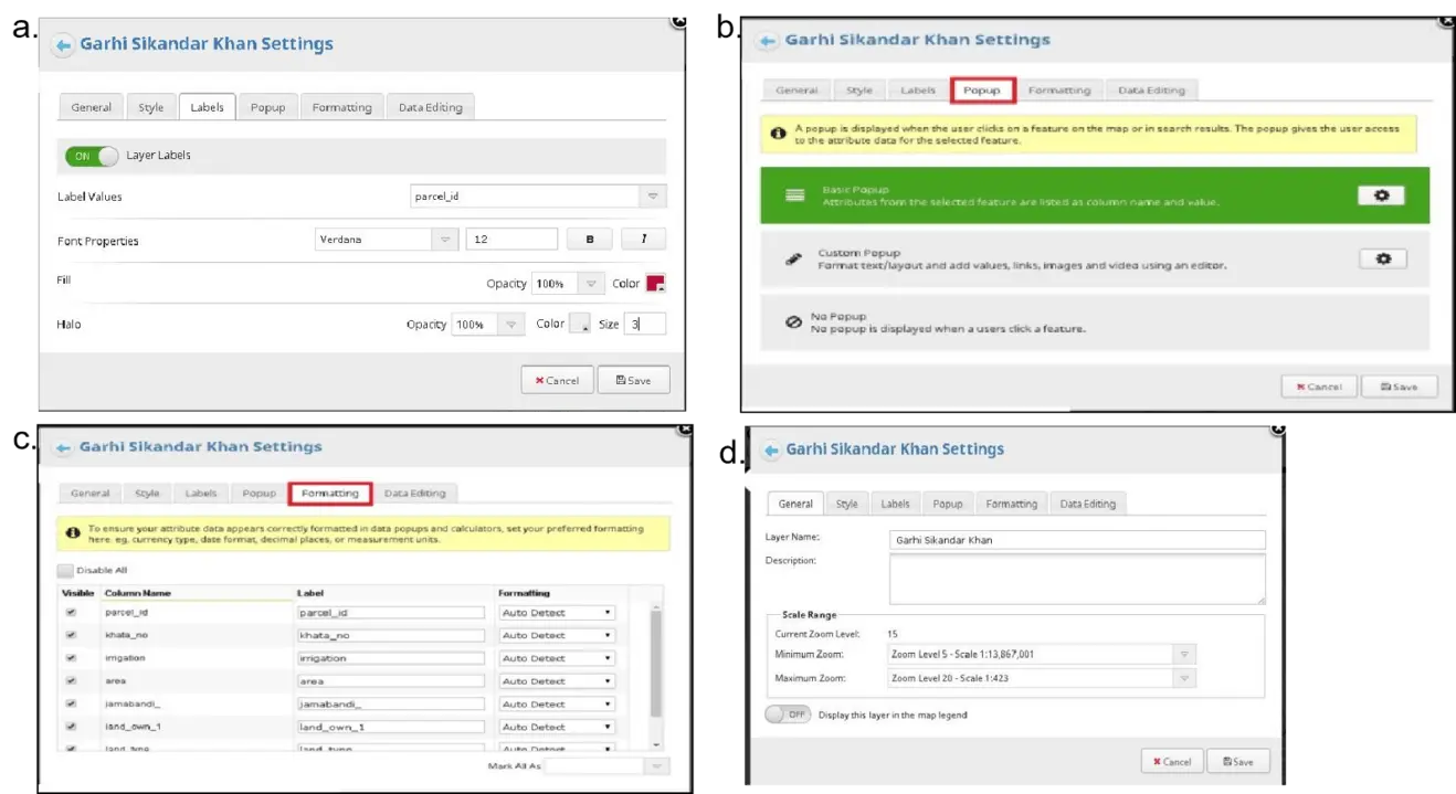
Figure 10. (a) Customization of title and description; (b) Customization of labels; (c) Customization of popup; (d) Customize title and description.
5. Conclusion
The LIS is the foundation of our study, representing a comprehensive land surface data adjustment system. In today’s world, the transition from traditional paper-based data to a dynamic digital format, represented by LIS, has become not just possible but necessary. This transformation is driven by advanced technological interventions, primarily utilizing the synergy of GIS and RS techniques.
The LIS framework is carefully designed with advanced computer programming principles, reflecting a strong focus on adaptability and reusability. Our main goal is to transform existing land-record data into a user-friendly computerized format using GIS technology. This complex procedure entails scanning, georeferencing, and digitally converting revenue maps, resulting in the seamless integration of attribute data with geographical data. The culmination of this project is the development of an advanced and efficiently structured database system, a repository filled with land-related geographical and attribute data.
Additionally, our secondary goal is to make this vast amount of digital information accessible to everyone. In order to achieve this, we have utilized the capabilities of the Mangomap Server to create a web-based interface that is easy to use, allowing for effortless uploading and retrieval of digital data. This gateway not only connects people across the digital divide but also offers improved efficiency and collaboration.
The study is carefully organized, with multiple sources and GIS working together seamlessly. It is supported by a well-designed architecture that can easily incorporate new data assimilation extensions. The Digital Cadastral Land Information System (DCLIS) is a powerful tool that serves as the backbone for efficient and flexible land resource computations.
The DCLIS is a powerful tool for quickly updating datasets and improving them, allowing for a wide range of data integration strategies. The system excels at combining various models of the land surface with great precision, utilizing high-resolution remotely sensed data, including inputs from NASA’s Earth science sensors.
We are dedicated to constantly improving our work, with a particular emphasis on fine-tuning the DCLIS framework. It supports different running modes and uses attributes to create smoothing and variation techniques for a range of data assimilation methods. The complete collection of data is readily available for exploration and analysis via the user-friendly web-based DCLIS interface. This platform provides a panoramic view of land-related insights, accessible to both the general public and governmental entities.
Future work aims to enhance the functionality and usability of the LIS framework. By integrating cutting-edge machine learning algorithms into the system, its ability to generate valuable insights and predictions could be significantly improved. In addition, by incorporating real-time data streams and promoting collaboration with meteorological and environmental agencies, the LIS can enhance its ability to adapt to evolving environmental conditions.
Moreover, considering the LIS as a platform for community engagement and decision-making has the potential to empower local stakeholders in land management and planning. Integrating user-friendly interfaces and tools for public participation can greatly enhance the LIS, making it a valuable resource for professionals and citizens alike.
As we explore new frontiers in technology and face ever-changing environmental issues, the LIS continues to be a symbol of innovation. The potential applications are incredibly diverse, spanning across a wide range of landscapes. This ongoing journey is not just about data; it’s about revolutionizing the way we see, engage with, and protect our valuable land resources.
Authors contribution
All authors contributed equally to this work.
Conflicts of interest
The authors declare that there are no conflicts of interest.
Ethical approval
Not applicable.
Consent to participate
Not applicable.
Consent for publication
Not applicable.
Availability of data and materials
The data and materials could be obtained from the corresponding author.
Funding information
None.
Copyright
© The Author(s) 2024.
References
-
1. Dale PF, McLaughlin JD. Land information management. An introduction with special reference to cadastral problems in third world countries. Oxford: Clarendon Press; 1988.
-
2. Ibrahim I, Daud D, Azmi FAM, Noor NAM, Yusoff NSM. Improvement Of land administration system in Nigeria: a blockchain technology review. Int J Sci Res. 2021;10(08):33-39. Available from: http://www.ijstr.org/final-print/aug2021/Improvement-Of-Land-Administration-System-In-Nigeria-A-Blockchain-Technology-Review.pdf
-
3. Ameen K. Challenges of preparing LIS professionals for leadership roles in Pakistan. J Educ Libr Inf Sci. 2006;47(3):200-217.[DOI]
-
4. Kineber AF, Mohandes SR, ElBehairy H, Chileshe N, Zayed T, Fathy U. Towards smart and sustainable urban management: A novel value engineering decision-making model for sewer projects. J Clean Prod. 2022;375(2):134069.[DOI]
-
5. Rigaux P, Scholl M, Voisard A. Spatial databases: with application to GIS. Amsterdam: Elsevier, 2001.
-
6. Ali Z, Shakir M. Implementing gis-based cadastral and land information system in Pakistan. J Settlements Spat Plan. 2012;3(1):43-49. Available from: https://geografie.ubbcluj.ro/ccau/jssp/arhiva1_2012/06JSSP012012.pdf
-
7. Verburg PH, Verburg K, Nol L. Challenges in using land use and land cover data for global change studies. Glob Chang Biol. 2011;17(2):974-989.[DOI]
-
8. Justice CO, Townshend JRG, Vermote EF, Masuoka E, Wolfe RE, Saleous N, et al. An overview of MODIS land data processing and product status. Remote Sens Environ. 2002;83(1-2):3-15.[DOI]
-
9. Waqas H, Jiang Y, Shang J, Munir I, Khan FU. An integrated approach for 3D solar potential assessment at the city scale. Remote Sens. 2023;15(23):5616.[DOI]
-
10. Williamson IP, Wallace J. New roles of land administration systems. In: International workshop on good land administration-its role in economic development; 2007; Ulaanbaatar, Mongolia. Available from: https://rest.neptune-prod.its.unimelb.edu.au/server/api/core/bitstreams/8e044826-e11a-57b4-9ff9-0a60e74a18f1/content
-
11. Nahrin K, Rahman MSU. Land Information System (LIS) for land administration and management in Bangladesh. J Bangladesh Inst Planners. 2009;2:116-125.[DOI]
-
12. Ansah BO, Voss W, Asiama KO, Wuni IY. A systematic review of the institutional success factors for blockchain-based land administration. Land Use Policy. 2023;125:106473.[DOI]
-
13. Bogaerts T, Zevenbergen J. Cadastral systems-alternatives. Comput Environ Urban Syst. 2001;25:325-337.[DOI]
-
14. Waqas H, Shang J, Munir I, Ullah S, Khan R, Tayyab M, et al. Enhancement of the energy performance of an existing building using a parametric approach. J Energy Eng. 2023;149(1):1-15.[DOI]
-
15. Henssen J. Basic principles of the main cadastral systems in the world. Available from: https://www.fig.net/Delft_seminar_95/paper2.html
-
16. Enemark S. Land administration infrastructures for sustainable development. Prop Manag. 2001;19(5):366-383.[DOI]
-
17. Abdelhamid MMA, Mousa BG, Waqas H, Elkotb MA, Eldin SM, Munir I, et al. Artificial thermal quenching and salt crystallization weathering processes for the assessment of long-term degradation characteristics of some sedimentary rocks. Egypt Minerals. 2022;12(11):1393.[DOI]
-
18. Enemark S. Building land information policies. In: Proceedings of the UN, FIG, PC IDEA Inter-regional Special Forum on The Building of Land Information Policies in the Americas; 2004 Oct 26-27; Aguascalientes, Mexico. Available from: https://www.fig.net/resources/proceedings/2004/mexico/papers_eng/ts2_enemark_eng.pdf
-
19. Khan R, Li H, Basir M, Chen YL, Sajjad MM, Haq IU, et al. Monitoring land use land cover changes and its impacts on land surface temperature over Mardan and Charsadda Districts, Khyber Pakhtunkhwa (KP), Pakistan. Environ Monit Assess. 2022;194(6):409.[DOI]
-
20. Saeed M, Li H, Ullah S, Rahman A-u, Ali A, Khan R, et al. Flood hazard zonation using an artificial neural network model: a case study of Kabul River Basin, Pakistan. Sustainability. 2021;13(24):13953.[DOI]
-
21. Tariq A, Shu H, Siddiqui S, HYPERLINK "https://www.tandfonline.com/author/Mousa%2C+B+G" Mousa BG, HYPERLINK "https://www.semanticscholar.org/author/I.-Munir/40139170" Munir I, Nasri A, et al. Forest fire monitoring using spatial-statistical and Geo-spatial analysis of factors determining forest fire in Margalla Hills, Islamabad, Pakistan. Geomatics Nat Hazards Risk. 2021;12(1):1212-1233.[DOI]
-
22. Siddiqui MB, Straquadine GS. Sustainable agriculture ensures sustainable rural development: a reality or a myth. In: Behnassi N, Draggan S, Yaya S, editors. Glob Food Insecurity. New York: Springer. 2011. p. 21-32. [DOI:10.1007/978-94-007-0890-7_3].[DOI]
-
23. Waqas H, Lu L, Tariq A, Li Q, Baqa MF, Xing J, et al. Flash flood susceptibility assessment and zonation using an integrating analytic hierarchy process and frequency ratio model for the Chitral District, Khyber Pakhtunkhwa. Pakistan Water. 2021;13(12):1650.[DOI]
-
24. Tayyab M, Zhang J, Hussain M, Ullah S, Liu X, Khan SN, et al. Gis-based urban flood resilience assessment using urban flood resilience model: a case study of Peshawar city, Khyber Pakhtunkhwa, Pakistan. Remote Sens. 2021;13 (10):1864.[DOI]
-
25. Khan R, Li H, Afzal Z, Basir M, Arif M, Hassan W. Monitoring subsidence in urban area by PSInSAR: A case study of Abbottabad City, Northern Pakistan. Remote Sens. 2021;13 (9):1651.[DOI]
-
26. Yìldiz O, Coruhlu YE, Biyik C. Registration of agricultural areas towards the development of a future Turkish cadastral system. Land Use Policy. 2018;78:207-218.[DOI]
-
27. van Weel C, Rosser WW. Improving health care globally: a critical review of the necessity of family medicine research and recommendations to build research capacity. Ann Fam Med. 2004;2:S5-S16.[DOI]
-
28. Dale P, McLaughlin J. Land administration. Oxford: Oxford University Press. 2000.
-
29. Dawidowicz A, Radzewicz A, Renigier-Biłozor M. Algorithm for purposes of determining real estate markets efficiency with help of land administration system. Surv Rev. 2014;46(336):189-204.[DOI]
-
30. Tominski C, Schumann H, Andrienko G, HYPERLINK "https://ieeexplore.ieee.org/author/37283047700" Andrienko N. Stacking-based visualization of trajectory attribute data. IEEE Trans. Vis Comput Graph. 2012;18(12):2565-2574.[DOI]
-
31. Hughes J [Internet]. The philosophy of intellectual property. Geo LJ. 1988;77:287. Available from: https://justinhughes.net/docs/a-ip01.pdf
-
32. Niroula GS, Thapa GB. Impacts and causes of land fragmentation, and lessons learned from land consolidation in South Asia. Land Use Policy. 2005;22(4):358-372.[DOI]
-
33. Raza F, Almas M, Ahmed K. Land records information management system. In: Proceedings of the 25th Annual ESRI International User Conference; San Diego, California. 2005. Available from: https://proceedings.esri.com/library/userconf/proc05/papers/pap1279.pdf
-
34. Maharjan HG. Land records information management system. J Geoinformatics Nepal. Journal on Geoinformatics, Nepal. 2017,14;26-31.[DOI]
-
35. Lamba A. Land tenure management systems in informal settlements [dissertation]. Twente Fac. Geo-Information Earth Obs. 2005. Available from: https://landportal.org/library/resources/land-tenure-management-systems-informal-settlements
-
36. Mehmood A [Internet]. Urban Pakistan State Pakistani Cities Rep. 2014. Available from: https://www.academia.edu/16445017/Urban_Pakistan_Report
-
37. Khan SR, Akhtar AS, Bodla S. The military and denied development in the Pakistani Punjab: An eroding social consensus. London: Anthem Press; 2014.
-
38. Goodchild MF, Haining RP. GIS and spatial data analysis: Converging perspectives. Papers Reg Sci. 2003;83:363-385.[DOI]
-
39. Burkhard B, Kroll F, Nedkov S, Müller F. Mapping ecosystem service supply, demand and budgets. Ecol Indic. 2012;21:17-29.[DOI]
-
40. Ngilimana G, Mukuru SA, Rwabukumba KV. Information system usage and land management: a case study of Nyanza district, Rwanda. World J Eng Res Technol. 2018;4(6):279-300.. Available from: https://www.wjert.org/article_issue/29102018/1543308267.pdf
-
41. Unger DR, Hung I-K, Zhang Y, Parker J, Kulhavy DL, Coble DW. Accuracy assessment of perimeter and area calculations using consumer-grade global positioning system (GPS) units in southern forests. South J Appl For. 2013;37(4):208-215.[DOI]
-
42. Gopi S, Sathikumar R, Madhu N. Advanced surveying: total station, GIS and remote sensing. 2 ne ed. Pearson Education India. 2007.
-
43. Kux D. The United States and Pakistan, 1947-2000: Disenchanted Allies. Woodrow Wilson Center Press, 2001.
-
44. Rubab I, Malik B, Bakht Aziz Z. Do Legal and Institutional Reforms in Punjab, Pakistan Protect Women’s Inherited Land Rights? J Int Womens Stud. 2023;25(4):5. Available from:https://vc.bridgew.edu/jiws/vol25/iss4/5
-
45. Imtiaz A, Shehzad D, Khan I, Imran A, Muhammad A. A comprehensive survey on blockchain technology applications in different sectors of Pakistan to develop smart cities. Pakistan J Emerg Sci Technol. 2023;4(3):82-94.[DOI]
-
46. Mahmood K. IDENTIFIERS* Library Computer Systems; Pakistan, 1998.
-
47. Mearns R. Access to land in rural India: policy issues and options. World Bank Publications; 1999.
-
48. Enemark S. Land information systems and planning-is decentralisation a significant key to sustainable development. Prop Manag. 2001;19(5):366-383.[DOI]
-
49. Sevatdal JF, Adeel MI. Country Report, 2012.
-
50. Khan MA. Land Record Management Information System in Punjab, 2020.
-
51. Underkuffler LS. On property: An essay. Yale Law J. 1990;100(1):127-148.[DOI]
-
52. Imran S, Ferdous T, Adeel M, Faheem M. Existing land record management system of Pakistan and proposed Arc GIS parcel data model. In: 2013 International Conference on Aerospace Science & Engineering (ICASE); 2013 Aug 21-23; Islamabad, Pakistan. New York: IEEE; 2013. p. 1-6.[DOI]
Copyright
© The Author(s) 2024. This is an Open Access article licensed under a Creative Commons Attribution 4.0 International License (https://creativecommons.org/licenses/by/4.0/), which permits unrestricted use, sharing, adaptation, distribution and reproduction in any medium or format, for any purpose, even commercially, as long as you give appropriate credit to the original author(s) and the source, provide a link to the Creative Commons license, and indicate if changes were made.
Publisher’s Note
Share And Cite

